Photogrammetry - 3D Modelling
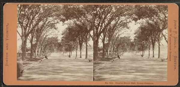
Image Based 3D Modeling is the process of creating a three dimensional representation out of photographs. There are two main approaches to this process: Stereo imaging and Photogrammetry.
Stereo Image Based 3D Modeling is the process of creating a 3D file solely out of two photographs.
The underlying principle of Stereo Image Based 3D Modeling is photogrammetry and stereoscopic vision. Stereoscopic images have been around nearly as long as photography. Indeed, stereoscopic photography began to flourish back in the 1850's. Special stereoscopic cameras and viewers were extremely popular and the demand for stereo images of scenes both far and near grew well into the latter part of the century. (http://en.wikipedia.org/wiki/Stereoscopy)
However, while the 19th century images were both novel and exciting, their usefulness was limited to the pleasure of viewing. It was only with the development of the principles of photogrammetry by C.Pulfrich (1901) that the stereo image began to become a tool for analysis and interaction.
Photogrammetry is the “science of measuring in photos”, and is most commonly used in remote sensing, aerial photography, archaeology, architecture and other fields where we need to determine measurements from photographs.
It is based on the principle that while a single photograph can only yield two-dimensional coordinates, height and width, two overlapping images of the same scene, taken slightly apart from each other can allow the third dimension (depth) to be calculated.
This is much the same way as the human visual system generates depth perception from the images projected by our two eyes.
We are able to see objects in three dimensions, judge volume, distance and relative size, all because of our stereoscopic vision. This is due to the fact that our brain receives two slightly different images resulting from the different positions of the left and the right eye and due to the fact of the eye’s central perspective.
This principle of stereoscopic viewing is the underlying principle of photogrammetry.
If two photos are taken of the same object but from slightly different positions, one may calculate the three-dimensional coordinates of any point which is represented in both photos. The two camera positions view the object from so-called "lines of sight". These lines of sight are mathematically intersected to produce the 3-dimensional coordinates of the points of interest. This same principle of triangulation is also the way our two eyes work together to gauge distance.
More on the topic of photogrammetry and stereoscopic vision can be found online.
Analytical Photogrammetry
The rapid development of the computer after the 2nd world war saw the beginnings of analytical photogrammetry and algebraic based formulas which advanced digital aerial triangulation. However, the advent of the digital photograph and advanced software for image data processing saw this evolution bloom into a fast and practical field for interactive photographic imaging.
Today, a large number of photogrammetric based software solutions exist on the market. Some are based on multiple images and use triangulation principles much like 3D scanners, while others use the stereo image principle.
It is important however to remember that stereo imaging is not 3D photographic modeling. The camera, like the human eye can not calculate what it cannot see. It may guess, extrapolate, average, calculate and estimate based on the information available. However, true depth calculation can be performed only if the area in question was captured by the imaging system. In two overlapping images there will be large areas of information absent by occlusion. Nevertheless, even if full, and analytically accurate information is not present, interactive stereo images can greatly enhance our perception of the object. This is most apparent in reliefs, three dimensional surfaces and rough textures.
Full scale photogrammetry, on the other hand will attempt to cover the area in question from multitude of angles, thus allowing the full recreation of a measurable 3d reproduction of the subject.
The following video outlines the process that was carried out in the cemetery.
Photogrammetry in Bad Neustadt
One of the central applications of imaging in this project was the mapping out of the cemetery, reproducing an accurate floor plan and providing both virtual access to the site and tagging the graves with as much information as possible.
The original plan was to base the map on aerial photography. However, it soon became apparent that two obstacles lay in our path. One financial and the other physical. Commissioning an aerial survey of the site would not be possible financially and no suitable up to date low level images were found. Google images were nowhere near high enough in resolution and were thus not of any real use. Over more, it became apparent that approximately half the area of the cemetery was hidden from site under a thick canopy of trees, rendering aerial imaging or even mast photography ineffective. To overcome this limitation aerial LiDAR scanning could be an effective solution. The LiDAR (Light Detection And Ranging) scanner is an optical sensor that measures the distance and other properties of an object by illuminating it with a laser and analysing the returned light. This technique can penetrate the overgrowth and the resulting Digital Terrain Model ("DTM") can show the hidden surface. However this too was not a practical solution due to cost. It was therefore decided to apply ground level photogrammetry for the purpose.
For the 3d area mapping, the Autodesk Recap a Photo software was chosen. This is a cloud based service, designed to enable the construction of 3d models based on photogrammetry. Autodesk introduced ReCap photo recently as an upgrade to its original 123D Catch, a mobile app for consumers that turned photographs into 3D models. This highly improved version allows an unlimited number of overlapping photographs taken at different angles around an object to be converted into a massive point cloud, and creates high-resolution, textured 3D. The software leverages the cloud to process and store the photos and data. In our case, it was not so much the textured 3d model that was of interest, but rather the ability to reconstruct the surface area with relative accuracy and then move the virtual 3d camera to an elevated position and create a simulated aerial view of the cemetery layout